| Home |
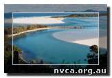
Nambucca Estuary
The special characteristics of the Nambucca Estuary make it a popular recreational river, with marine sands giving it an aquamarine colour perfect for swimming and snorkelling. The river is used by pleasure boats and sports crafts, by oyster growers and small commercial fishing enterprises.
The town of Nambucca is located at the entrance and Macksville is approximately 13 km upstream of the entrance. The estuary extends up the Nambucca River from Nambucca Heads to the town of Bowraville, and along Warrell Creek past Scotts Head out to the Pacific Highway. The area it covers is approximately 7.74 km2 and it drains a catchment of 1,460 km2.
The main arm of the river is approximately 76 km long, with the tidal limit 28 km from the entrance, and is navigable to approximately 5 km upstream of Macksville. Despite extensive clearing to the river edge, there are remnants of diverse riparian vegetation.
Estuaries are places of transition, where water from the land meets and mixes with the open sea, and are found at the lower end of rivers. The major estuarine tributaries feeding into the Nambucca River are Taylors Creek, Newee Creek, Watt Creek, Taylors Arm, Swampy Creek and Warrell Creek.
The permanent entrance at Nambucca Heads is trained with a single northern wall and is shallow and very hazardous. 55% of the catchment is zoned rural, 40% State Forest and of the remainder 1.6% Environmental Protection and 1.9% National Park.
The upper catchment contains the steep and rugged eastern edges of the New England Plateau and the lower catchment includes the fertile floodplains of the Nambucca River and Taylors Arm. These and adjacent undulating lands have been cleared extensively for agriculture, predominantly beef and dairy cattle with some cropping and horticulture including banana and macadamia nut production.
The floodplains of the Nambucca River are characterised by gravel soils with high permeability, low water holding capacity, high top soil fertility, localised poor drainage and seasonal waterlogging, resulting in localised flood hazards. Where the riparian vegetation has been removed, severe stream bank erosion has occurred causing large areas of floodplain to be eroded into the river. Extensive, inappropriate sand and gravel extraction has also been cited as a contributing factor to degradation of the waterway.
Estuaries are often referred to as the “nurseries of the sea” because they are the breeding grounds for many fish, crustaceans, and other marine life. NSW has more than 130 estuaries of varying sizes that are of immense environmental, social and economic importance. They all contain diverse ecosystems that support vegetation, wildlife, and the coastal food-chain. Estuaries located close to towns, are very attractive to tourists and the preferred location for coastal development.
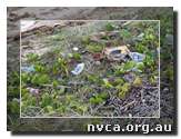
However, concern is growing about the negative effect that increasing coastal urbanisation is having on our environment including estuaries. Population growth and urbanisation are stressing and degrading our fragile coastal ecosystems. Habitat degradation, declining water quality, resource depletion, loss of amenity, and restricted access are just some of the issues of concern to local communities.
Nutrients, sediments and toxins created by urbanisation, agricultural activities, vegetation clearing and industry, eventually end up in an estuary affecting the water quality and life within it. In this way estuaries can be considered as the report cards of the catchments. Dams and water extraction for irrigation and water supply alter the hydrology of estuaries and may lead to increased salinity in the upper reaches of the tidal pool increasing sedimentation, closed entrances, altered freshwater flows and changes in tidal flushing. These changes can have profound impacts on estuarine and coastal ecosystems.
The physical, chemical and biological processes of an estuary are highly integrated, each component acting on the other to determine the type of ecological conditions. For example, inputs into the system and tidal processes directly affect physical processes within the estuary which affect the chemical processes which then determine the existing ecology. Nature adapts to these changes.
Our perceptions of what rivers, creeks and estuaries should look like as well as our expectations for using these areas may need to accommodate the fact that these natural environments have been modified over time by human activity. Their sensitivity to changes should be a guiding factor in how we treat them. – Coast and Estuary Resource Information Kit. |
|